


Headlines
- SPOTTY STORMS THROUGH FRIDAY
- POTENTIALLY HEAVY WEEKEND RAIN
- 100°+ HEAT INDEX NEXT WEEK
Heavy rain fell with thunderstorms this evening across many areas south of I-70. Below is estimated rainfall totals. High water might be an issue for some as you get going on Friday morning. Remember, do not drive through flooded roads.

On Friday, the chances of rain will be fairly low for most. The best chance for rain will actually be during the morning hours, with drier conditions expected in the afternoon. Temperatures will be seasonably high in the mid-80s, but the humidity will remain high, making it feel muggy.

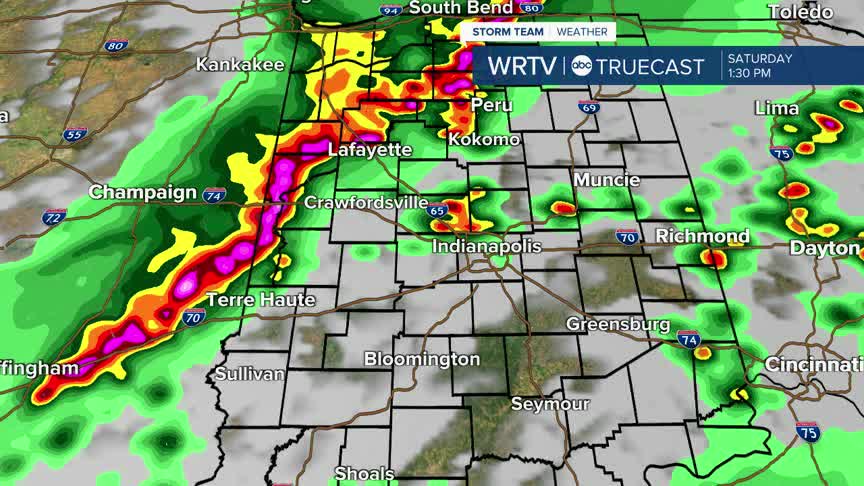
Once we reach the weekend, multiple rounds of storms will be possible, all of which could produce very heavy rainfall. On Saturday, there is a threat of severe storms in the afternoon and early evening hours, which is something we will need to keep an eye on.

With the potential for several rounds of heavy rain, some flooding is possible. Certain areas could receive 3 to 5 inches of rain over the course of Saturday and Sunday. The main threat from the severe weather will be gusty winds.

Next week, temperatures will climb into the low 90s, with dew points reaching the 80° range. Dew points this high are fairly rare for us and will make it feel like it's above 100° due to the heat index values for several days. This is dangerous heat, so make sure to plan ahead.
Indianapolis Weather Forecast:
Overnight: Partly cloudy. Spot shower. Low: 69°
Friday: Partly cloudy. Scattered T'Storms. High: 86°
Saturday: Potentially heavy rain. High: 87°
Sunday: Areas of rain. High: 86°
Indianapolis 7-Day Weather Forecast

